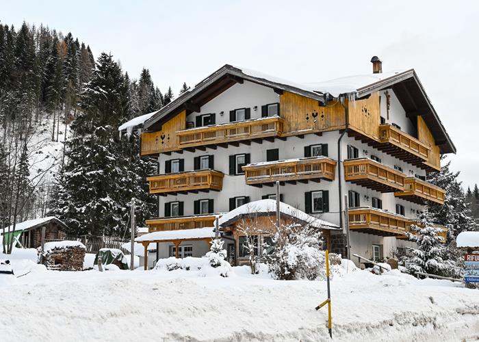
Gosaldo | Telefono: +39 351 8150470 | Cellulare: 3292170918
![]()
![]()


€ 30
€ 60
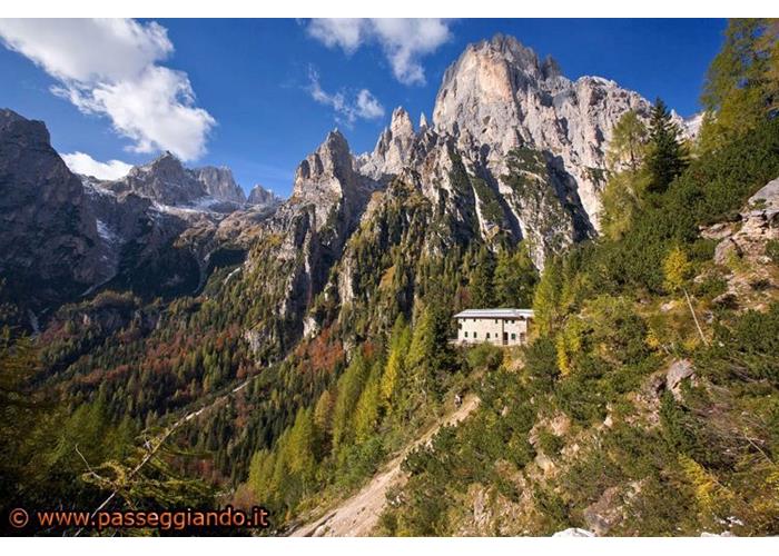
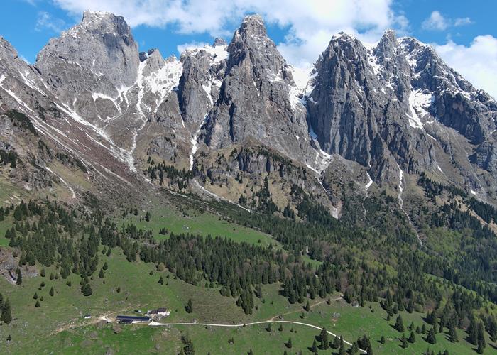
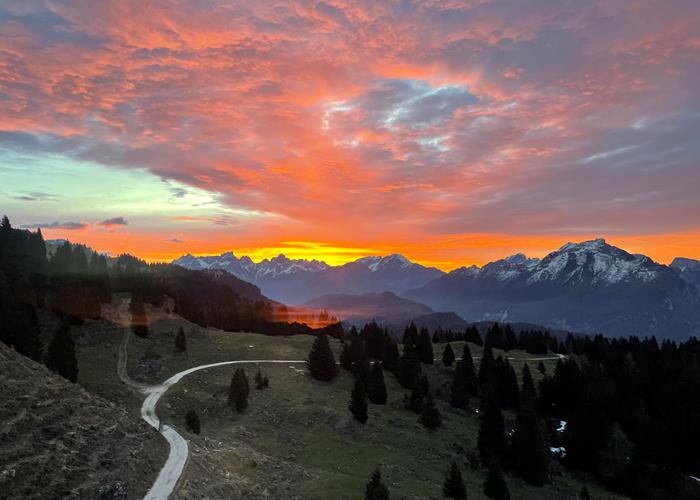
The refuge is located on the south-eastern side of the last bastions of the Pale di San Martino, on the edge of the Dolomiti Bellunesi National Park, at 1680 meters above sea level. In order to appreciate the beauty of the Dolomites it is increasingly necessary to respect the majestic beauty and simplicity that distinguishes them. We want to be among the guardians and not among too many predators in the delicate panorama of the Dolomites, a UNESCO heritage site that we have the honor and fortune of being able to have alongside us. We are with those who go to the mountains on tiptoe, to immerse themselves in nature, respecting its rhythms and seasons. We offer hospitality that respects the mountain ecosystem in which the refuge is located, using renewable energy and offering products, when possible, organic and preferably from a short supply chain. Our cuisine is made of quality in the choice of raw materials and we always work to create simple, supportive, clean relationships.
Read everythingFrom Sarasin di Gosaldo – loc. Domadore along the CAI 720 path, taking the forest road to Malga Cavallera up to the crossroads in Pra della Forca (difficulty: easy; 1.8 km for 350 meters of altitude difference). Leaving aside the junction with the path, it is also possible to continue along the forest road (difficulty: easy, 2.8 km with a difference in altitude of 350 metres): a recommended route for the less trained, for those who want to get on a bicycle, with a child carrier, in MTB or on horseback. From Passo Cereda along the CAI paths 718-777 (difficulty: hiking; 7.4 km for 880 meters of positive altitude difference). From Sant'Andrea di Gosaldo along the forest road to the Malga Cavallera refuge (difficulty: easy; 3.7 km with a difference in altitude of 400 metres). You go up on foot, by MTB, on skis, on snowshoes and on horseback; if you go up with small children it is preferable to use a child carrier. From the Scarpa – Gurekian refuge along the CAI 773 path (difficulty: hiking; 6.8 km for 270 meters of positive altitude difference). From the Treviso Refuge in Val Canali along the CAI 720 path (difficulty: hiking (the Forcella delle Mughe is not trivial, pay close attention); 3.4 km for 650 meters of positive altitude difference). We advise you against taking the path that starts near the Don di Gosaldo Pharmacy and which is signposted Malga Cavallera/Bivacco Menegazzi. The path passes through an area recently affected by logging and the path has been cut in several places by tractor tracks which make orientation much more complicated, making it easy for those who don't know the area well to get lost. THE FOREST ROADS FROM DOMADORE AND SANT'ANDREA DO NOT HAVE A BAR SINCE THEY SERVE MANY HUTS AND RURAL ACTIVITIES, HOWEVER THEY ARE SILVO PASTORALI ROADS WHICH CANNOT BE TRAVELED BY MOTOR VEHICLES EXCEPT WITH THE SPECIAL PERMIT ISSUED BY THE MUNICIPALITY OF GOSALDO AND ONLY FOR PROFESSIONAL REASONS.
Read everything
From the Cavallera Refuge to the Scarpa Gurekian Refuge
Route: medium-easy and about 200 meters of ups and downs
Travel time: 3 hours without stops at a medium pace.
Cartography; sheet 22 Pale di San Martino tobacco
From Rifugio Cavallera you can reach the Menegazzi Bivacco in a few minutes along path 720 and, leaving aside the climb towards the Forcella delle Mughe on the left, proceed to the right along path 773 crossing the beautiful meadows of Pian Lonch until you cross the stream that descends from the valley Sprit, this is the only complex passage of the entire itinerary as the Sprit stream digs its course every year in a very mobile scree and forces us to descend on a very steep stony surface for about twenty metres, up to the stream itself which then you cross easily. Once past the stream the path proceeds up and down and through other small streams that cut through the southern walls from Croda Granda to Casera Camp. Still keeping path 773, continue up to Col di Luna from where the panorama opens onto the majestic southern faces of Agner and the view extends as far as Moiazza and the Pale di San Sabastiano. Attention Col di Luna it is necessary to maintain path 773 and not deviate onto the wrong path following the Coston di Luna on the left or taking path 733 which goes down to Forcella Aurine (attention possible confusion between paths 773 and 733). From Col di Luna you continue on long and panoramic traverses on a grassy track and path without difficulty, seeing the villages of Don di Gosaldo and Forcella Aurine from above. You pass through the woods again for some stretches, the Pian dei Cavai area is very picturesque.
Before the last stretch out of the woods you begin to see the Scarpa-Gurekian Refuge which stands out on the top of its grassy hill. With a final climb you will shortly arrive at the refuge.
The return via the same route as the outward journey.
Possible deviations:
- visit to Malga Luna: just after the junction with path 772 that goes down to Frassenè you will find Malga Luna
- visit to the Tibetan temple which can be reached along the Coston di Luna via a very steep climb and not to be underestimated if the track is wet (ask the refuge management for precise directions)
- visit to the Pissandol waterfall, just before the climb that leads to Rif Scarpa, take a detour indicated with a wooden sign indicating Pissandol, it is a small seasonal waterfall, which after summer storms or during the thaw period covers a drop of a few metres.
From the Cereda Refuge to the Cavallera Refuge along the high path and return to Domadore
Route E demanding 800m D+ to be avoided in case of bad weather or slippery path.
Ring route
Travel time: approximately 6 hours with surefootedness.
Cartography; sheet 22 Pale di San Martino tobacco
From the Cereda refuge, take the road that goes up just behind the refuge itself until you take path 718 (which for this stretch corresponds to the route of the Alta Via n°2) until you reach the crossroads at the height of the climb to the Forcella d' Beyond with path 777 (not very obvious crossroads, pay attention). The route is fascinating, fun and very panoramic (view of the Pavione and the Piz de Sagron and the Conca Agordina) but challenging, especially for the first part which consists of a steep climb (about 500m D+) which immediately takes us up to altitude at the crossroads for the Regade pass (which we leave on our left), then the path proceeds through slight climbs and descents and takes us through grassy crossroads and some stony stretches under the ramparts of Monte Feltraio and then under the Rocchette (some stretches exposed in the watersheds not to be underestimated). From the junction with path 777 you lose altitude and arrive at a stretch of fir forest with a narrow but well-marked path up to the meadows that separate the Rifugio Cavallera from the Menegazzi bivouac. All you have to do is go down for a few more tens of meters to arrive in sight of the Refuge.
The return takes place along path 720 up to Domadore where you leave aside the asphalt road that goes down to the left towards Faustin/Sarasin and continue to the right along grassy tracks marked with a red mark up to the same driveway (closed to traffic) that you went uphill to go to the start of path 718. Continuing on the road you arrive near the Cereda refuge.
A panoramic variant during the climb could be to climb up to Forcella d'Oltro (from the junction with path 777 it is about 20 minutes of rapid climbing) to admire the verticality of Val Canali from the other side and then go back down to path 777 for the same route.
To the Treviso Refuge - Val Canali for the Forcella d'Oltro and return and for the Forcella delle Mughe
Route EE 1st difficult and demanding approximately 1200 m D+ (counting the ascent and descent from the two forks)
Travel time: approximately 6 hours at an average pace.
Cartography; sheet 22 tobacco Pale di San Martino Attention: in some older topographic maps and on some very old trail signs the Forcella delle Mughe is marked as Forcella delle Grave.
Circular route to be avoided in case of bad weather or in conditions of poor visibility. (the descent from the forks can become very complex due to orientation problems)
The two forks (both around 2300 m) are very impervious, and in the summit sections the Mughe fork has some first/second degree passages that should absolutely not be underestimated. Often the northern slopes of the forks still have snow-covered stretches until mid-June (better to ask at the Cavallera or Treviso refuges about the feasibility of the route before venturing out without the necessary tools).
From Rif. Cavallera, go up along path 777 to the junction with path 718 where you turn right towards the Forcella D'Oltro, after passing the fork, paying attention to the slippery ground, go down along the route of the Alta Via n°2 and take a right again, leaving aside the crossroads with path 718 B (also indicated as Troi dei Todeschi) and arrive by a traverse through mountain meadows and woods to the Treviso refuge.
From Rifugio Treviso the return begins along path 720 up to the Mughe fork and then always descends along path 720 (be careful to follow the trail signs that take us to the right just below the fork, if you are distracted you tend to proceed straight along the gully which, however, becomes difficult just below) After about 500 m D- you arrive near the Menegazzi bivouac and in a few steps you reach the Rif Cavallera.
A variant could be the short Via Ferrata del Canalone which climbs up from Rif Treviso and rejoins path 720 just above.
From Rifugio Cavallera to the top of Croda Granda via the Scalette pass and Via Normale
Ascent time: 4.00 hours
Entire route: 7.30 hours ascent difference in altitude: m. 1,650
Route EE 1st challenging and long not to be underestimated and with some orientation problems below the Scalette pass
Cartography: Tobacco sheet 022 Pale di San Martino
You go up from Rifugio Cavallera (1680m) along path 720 which arrives after a few minutes at the Menegazzi Bivacco (1737m, often full on weekends). You go up next to the flow of stones that descends along the slope, you gain about 200 meters of altitude until you reach a large boulder (dated wooden arrows). At the boulder, leave the path to the left for the possible crossing of the Forcella delle Mughe and instead proceed to the right beyond the bed of stones in a steep climb. Still on the left, we come to touch the first rocky buttresses and follow their base, guessing the continuation of the route (trail signs sometimes very distant from each other). Avoiding the fork above us and an old variant of the path that descends from the Forcella delle Mughe, we cut across all the gravels to the right following the few little men, bringing us close to the most accessible wall. This is found in the cards indicated as a step in the Ladders. The passage, well-staired and signposted, overcomes the drop of about fifteen meters where you have to use your hands and have a sure step, especially in the small final canal. Continue passing to the right of the Cima del Vani Alti on the bare plain, where you also intercept the path that passes through the Forcella dei Vani Alti (2519 m). Towards the south behind us now stands the Sass da Camp while we continue along the opposite stony shoulder under the Creste dei Vani alti until we come in sight of the Bivacco Reali. Finally we find ourselves in front of the Croda Granda which stands out on our right beyond a valley that we will have to cross (loss of altitude not to be underestimated). With caution we skirt the jump on the Sprit Valley itself, going down a good path on the boulders heavily furrowed by erosion that support the Reali Bivouac (well-equipped and clean support point with 6 cot places). Beyond the helicopter pad, we descend following the little men who guide us between the deep furrows and the jumps, pointing out the simplest route to the Forcella Sprit (2573 m). Near the fork, a track runs diagonally to the right towards a first snowfield (usually until mid-June) and the scree above. You pass a trickle of water (the only source of water in the whole area used by some in emergencies) and go up an easy stepped dihedral up to a comfortable ledge (1st lower) and from here we enter the gravel cone that can be seen from the bivouac. Choosing the most stable route in the debris, rather to the left, you aim for the upper notch that divides the Croda Granda from the Cima dei Róndoi. Here, always remaining below the ridge, you climb parallel to it, quickly gaining altitude passing through some slightly exposed stretches of simple climbing (1st) and some stretches where you proceed walking. There are still a few climbs left to overcome the leaps before the summit by following the green signs. A Madonnina and the summit book appear in front of us on the highest point (2849m).
Descent along the same path (about 3 and a half hours to Rif Cavallera) paying attention to the scree up to the base of Forcella Sprit which can be slippery on the descent.
Open from mid May - mid October
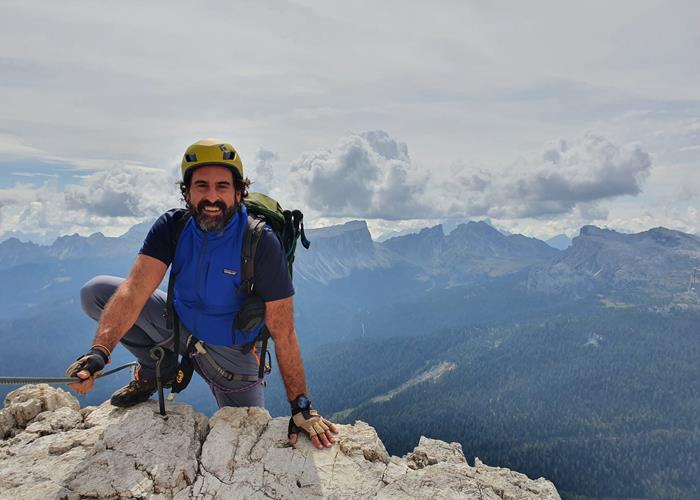
I have a background in Paleethnology at the University of Venice, I have always had a strong passion for adventure and discovery travel until it became a profession. After obtaining my naturalistic guide diploma in 2006 and having built solid experience in accompanying trekking in the Dolomites and in Italy, I began to accompany my first clients in Africa, mainly on adventurous trips in wonderful naturalistic contexts such as the course of the Zambezi and in the verdant hills of Uganda and East Africa. From 2003 to 2008 I managed the Naturalistic Education Center of the Veneto Region in Cansiglio, from 2012 to 2022 I managed Rifugio Alpe Madre i on the Monte Grappa massif and now together with my partner Luigi I manage the Rifugio Malga Cavallera in the Belluno part of the Pale group of San Martino, in the Dolomites.
Enter our shop to buy our gadgets, items for the mountains, stay packages in one of the mountain huts that are part of mountbnb.
Buy now
![]()
![]()