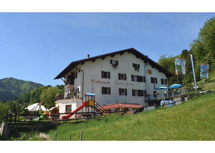
Brenzone | Telefono: +39 0457731797 | Cellulare: +39 3491389629
![]()
![]()
_021616_1006131596_700x500.jpg)
_021616_1006166439_700x500.jpg)
Vedi "Prezzi e Info" in descrizione
Vedi "Prezzi e Info" in descrizione
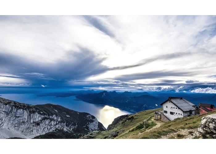
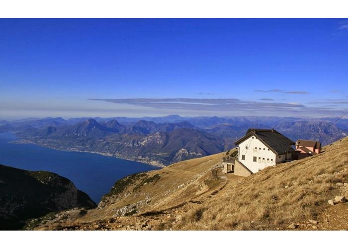
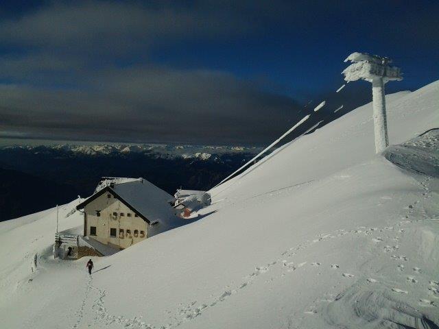
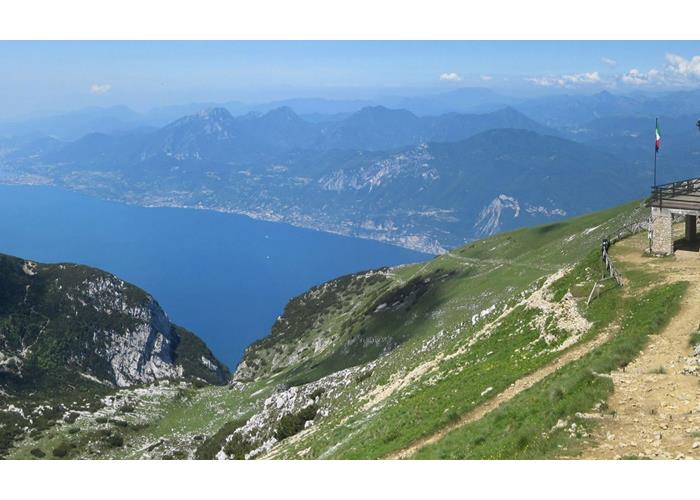
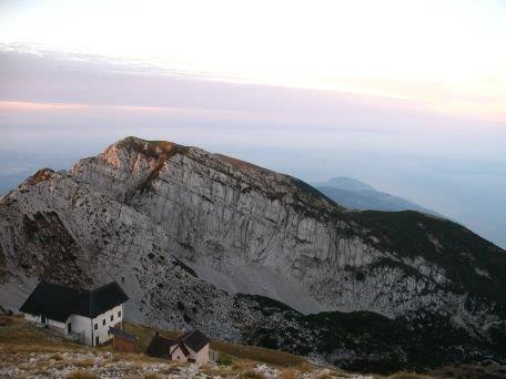
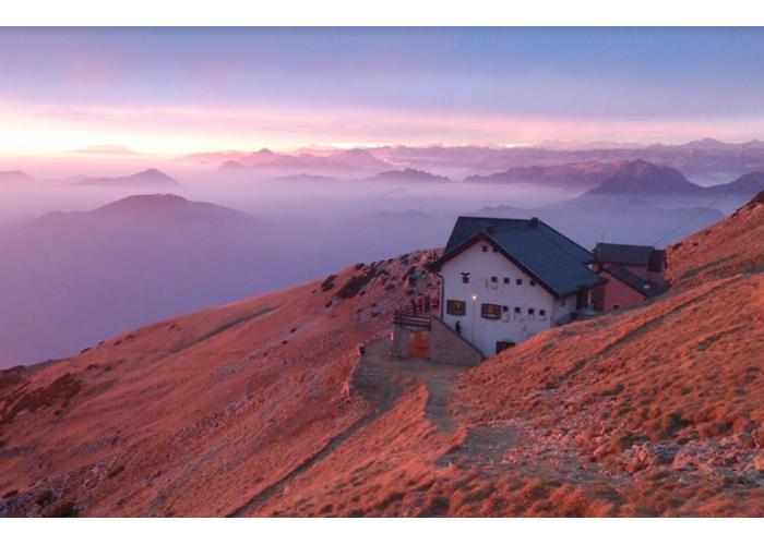
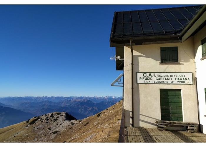
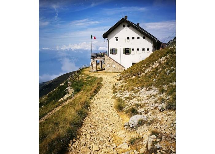
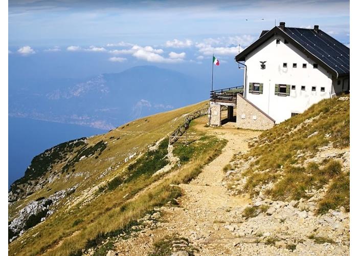
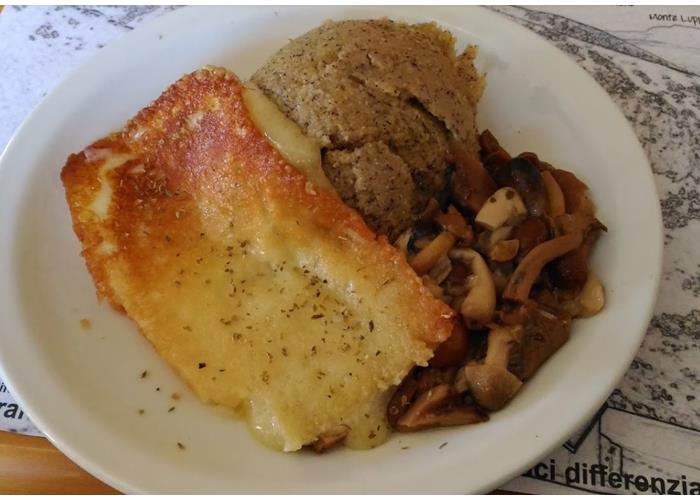
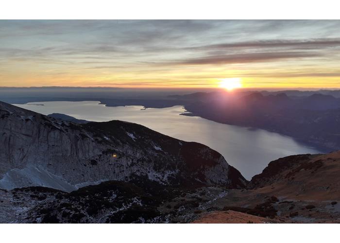
The TELEGRAFO "Gaetano Barana" alpine refuge (2147 m above sea level) is the highest of all the Monte Baldo refuges and dominates Lake Garda. It stands a short distance from the top of Monte Telegrafo, so called because from its summit Napoleon's informants sent optical signals downhill. The views and, above all, the sunsets that can be admired from the refuge are magnificent; There are numerous itineraries to follow to reach it. Efficient bar and restaurant service and ample availability of beds make this refuge a "must" destination for those who want to experience Monte Baldo!
Prices and Info
Here are all our suggestions for reaching us independently in the summer period.
ATTENTION!!
Path 659 from Cassone/Malcesine is CLOSED and IMPRACTICAL
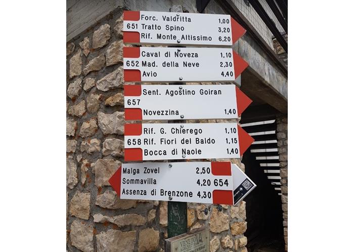
Prada-Costabella cable car + CAI path 658 from Rifugio Fiori del Baldo 1850m – Rifugio Telegrafo 2147m
Difficulty: Easy
Level of physical effort: 1 out of 5
Difference in altitude: 300m
Travel time: 1h
Main difficulties: none.
Description: the simplest itinerary ever to reach the refuge, obviously if you use the new "Prada-Costabella" basket lift and chair lift (info on how to reach the departure point, prices and opening hours by clicking here).
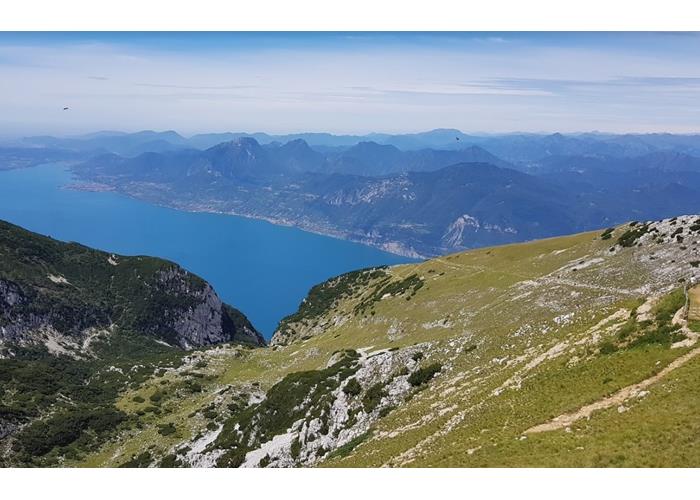
The route is suitable for everyone, as long as they have minimal equipment to tackle a mountain excursion at over 2000m above sea level, and takes place mainly on a military mule track, of moderate width and also practicable by mountain bike up to the "Passo del Camino" , about 35/40 minutes before departure. Beyond the pass, the mule track narrows a bit, but maintains the adequate width for a good mountain path. Along the entire itinerary you can constantly enjoy wonderful views of Lake Garda, the Adige Valley and the surrounding mountains.
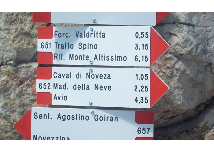
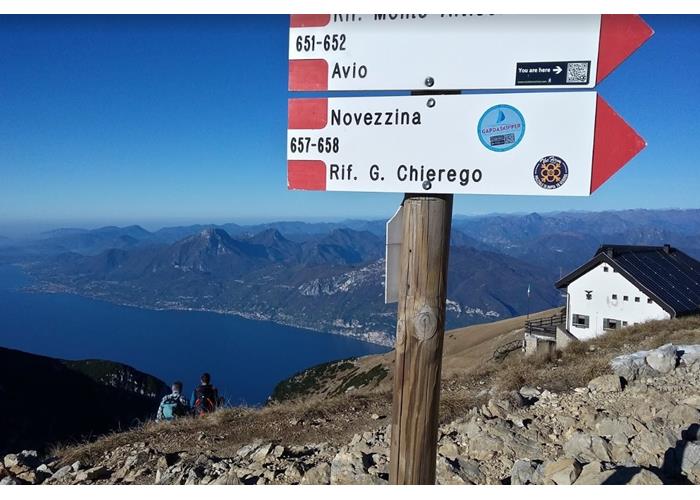
CAI paths 652 var. + 652 (Baito Novezza 1416m – Rifugio Telegrafo 2147m)
Difficulty: medium/high
Level of physical effort: 4 out of 5
Elevation gain: 760m
Travel time: 2h 15min
Main difficulties: presence of steep sections, with stony steps for about twenty minutes in the central part.
To avoid: travel during the hottest hours and by families with small children (<10 years) or those with knee problems, especially when going downhill.
Description: starts from Baito Novezza, a cheese and cured meat shop in Località Novezza di Ferrara di Monte Baldo and, compared to the next suggestion, allows for a wider and safer parking option. This is, in fact, the most direct access route to the refuge. The initial part does not always present an evident trail, but the poles with heads marked in white and red are clearly visible, other painted signs on stones and plants and the classic "cairns" to follow to easily face the first 20 minutes with a slope constant.
CAI path 652, “Bovi” or “Morocco” path (Strada Gen. Andrea Graziani 1555m – Rifugio Telegrafo 2147m)
Attention!! Departure not reachable in winter!!
Difficulty: medium/high
Level of physical effort: 4 out of 5
Difference in altitude: 620m
Travel time: 1h 45min
Main difficulties: presence of steep sections, with stony steps for about twenty minutes in the central part.
To avoid: travel during the hottest hours and by families with small children (<10 years) or those with knee problems, especially when going downhill.
Description: starts from a small car park on the side of the “Graziani” road a little (approx. 1km) further north of Novezza di Ferrara di Monte Baldo, already in Trentino territory.
CAI path 657, “Agostino Goiran” (Novezzina 1255m – Rifugio Telegrafo 2147m)
Difficulty: medium
Level of physical effort: 3 out of 5
Difference in altitude: 920m
Travel time: 2h 45min
Main difficulties: none.
Description: starts from a small car park on the side of the “Graziani” road, more precisely from the second hairpin bend after the botanical garden of Monte Baldo di Novezzina di Ferrara di Monte Baldo.
We recommend this trail to families and to those who have problems tackling steep and stony sections. It is a long path, but it is the most comfortable way up to the refuge.
CAI path 651 (Mountain station “Malcesine – Monte Baldo” cable car 1753m – Telegrafo refuge 2147m)
Difficulty: high
Level of physical effort: 4 out of 5
Elevation difference: 600m
Travel time: 4h / 5h
Main difficulties: long traverse across the Monte Baldo ridge line, without too steep sections, but with some exposed passages.
To avoid: by families with children and those with little training.
Description: starts from the mountain station of the Malcesine – Monte Baldo cable car, reachable, obviously, with the cable car itself. Magnificent itinerary from a landscape point of view that we recommend experiencing in peace, spanning two days, staying overnight in a refuge and then returning to Malcesine on the second day.
CAI path 654 (Val delle Nogare 1100m – Rifugio Telegrafo 2147m)
Difficulty: medium/high
Difference in altitude: 1050m
Level of physical effort: 4 out of 5
Travel time: 2h 45min /3h
Main difficulties: if you follow the "Forcellin" variant you face steep and exposed sections.
To avoid: the "Forcellin" variant by families with children.
Description: starts from a small car park on the side of the “Val Trovai / Punta Veleno” road (4km north of the car park of the old Prada-Costabella cable car).
CAI path 654 (Assenza 65m – Rifugio Telegrafo 2147m)
Difficulty: high
Level of physical effort: 5 out of 5
Difference in altitude: 2100m
Travel time: 6h
Main difficulties: long
CAI path 654 (Assenza 65m – Rifugio Telegrafo 2147m)
Difficulty: high
Level of physical effort: 5 out of 5
Difference in altitude: 2100m
Travel time: 6h
Main difficulties: long and demanding climb to the refuge, but a wide-ranging itinerary that connects Garda to the highest refuge on Monte Baldo. It is useful to include an overnight stay in a refuge. If you decide to follow the "Forcellin" variant, you will face steep and exposed sections.
To avoid: if not trained.
Description: starts from the main square of Assenza di Brenzone, practically on the shore of Lake Garda.
CAI paths 656 “Lino Ottaviani” + 658 (Valfredda 1321m – Rifugio Telegrafo 2147m)
Difficulty: medium
Level of physical effort: 3 out of 5
Elevation difference: 880m
Travel time: 2h 45min
Main difficulties: none.
Description: long itinerary, but with a pleasant distribution of altitude and a broad view of Garda. It begins with a stretch of path dedicated to the Alpine Guide Lino Ottaviani and which starts from the hairpin bend along the road that connects the "Graziani" with Valfredda, near the Valfredda Crocetta hut. To get there, once you reach Spiazzi, keep left towards Novezza. After about 2km, turn left again to first reach the Malga Ime farmhouse, then the starting point.
CAI paths 51 + 55 (“Due Pozze” 1298m – Baito Turri/Ex Rifugio Mondini 1554m – Rifugio Telegrafo 2147m)
Difficulty: medium
Level of physical effort: 4 out of 5
Elevation difference: 950m
Travel time: 3h 30min / 4h
Main difficulties: none.
Description: long, but exciting itinerary that runs along the beautiful balcony overlooking Garda between the locality “Due Pozze” and the Rifugio Telegrafo, passing through Val Vaccara, Baito delle Buse, Val delle Prè. Start from the car park in the locality "Due Pozze" reachable from the provincial road that goes up from San Zeno di Montagna to Prada: as soon as you pass the "Prada" sign you will find a narrow asphalt road on the right and signs for the "Fiori del Baldo" refuge. In 5km of road you will reach the car park where the itinerary starts from.
Military/Forestry Road “Due Pozze” 1298m – Fiori del Baldo and Chierego Refuge – Telegrafo Refuge 2147m
ATTENTION: itinerary to follow for those who wish to climb, partially by mountain bike.
Difficulty: Easy
Level of physical effort: 2 out of 5
Elevation difference: 750m
Travel time: 3h
Main difficulties: none.
Description: long itinerary that follows the military road that initially climbs to the Fort of Nàole (not necessarily to be reached) and then continues to the “Fiori del Baldo” and “Chierego” refuges. Follow the military road up to the “Passo del Camino” 2128m, and then follow the mule track in a beautiful, purely Alpine context. For those riding bikes, please dismount in these sections and respect hikers on foot.
This itinerary also starts from the car park in the locality "Due Pozze" reachable from the provincial road that goes up from San Zeno di Montagna to Prada: as soon as you pass the "Prada" sign you will find a narrow asphalt road on the right and signs for the "Fiori del Baldo" refuge ”. In 5km of road you will reach the car park where the itinerary starts from.
CAI path 655 + VARIOUS ALTERNATIVES (Prada 995m – Rifugio Telegrafo 2147m)
Difficulty: medium/high
Level of physical effort: 4 out of 5
Difference in altitude: approximately 1200m
Travel time: 4h
Main difficulties: pay attention to the start and orientation along the first part of the path; taking path 655 between the houses just downstream from the old cable car station, you reach the Baiti di Ortigara and from here you can follow various uphill routes.
To avoid: by families with children and those with little training.
Description: you can park at the Prada-Costabella cable car car park and follow the signs to go up the “Val da Sacco”; considering the various possibilities of ascent from the Baiti di Ortigara onwards, it is advisable to tackle the route equipped with a topographic hiking map.
From the refuge, climb a short path to the clearly visible summit of Punta Telegrafo with its summit cross. From Punta Telegrafo (2,200), an exceptionally panoramic point, you can return to the refuge and descend onto the Sen. 654 "difficulty E for Hikers", or head towards the West ridge and descend along the ridge "difficulty EE for Experts", in this case, aim for a cross that stands on a promontory. Having reached the Iron Cross (2.125) along the descent ridge, as soon as the rocks end, turn south-west until you reach path 654. Having reached the path, follow it until the intersection with tables. At the crossroads with CAI signs (1,965), there are two possibilities, the classic 654 (easier) which descends to the valley floor and the 654 variant which descends to Forcellin (exposed sections), which is more panoramic. The two routes will then rejoin on the sen. 654 main. At the crossroads (1.424), where the variant merges with the sen. Main 654 continue on this, from around 1300 m altitude the path crosses a forest road numerous times, here you keep to the path; towards an altitude of 1200 the path comes out on a forest road and no longer continues. We follow the forest road to the left for 200 metres, then we take a path that descends towards the SW (to the right), we keep it until the asphalt. Once you arrive on the asphalt road, which goes up from Porto di Brenzone, take a southerly direction until the car park.
Read everythingWeekend at the end of April, May, October Continuous June-September Sundays in November until 8 December
Enter our shop to buy our gadgets, items for the mountains, stay packages in one of the mountain huts that are part of mountbnb.
Buy now
![]()
![]()